
Forum Replies Created
-
AuthorPosts
-
 Graham DavisParticipant
Why the deuce does this silly system keep losing my replies? Aargh!
OK, let’s try again.
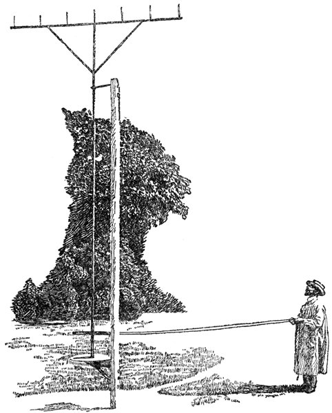
I first used a nephoscope in 1962 when I joined the Met Office. It was a Besson comb nephoscope and looked vaguely similar to this:
https://www.gutenberg.org/files/47059/47059-h/images/illus093.jpg
Not as gaudy as the version you wanted but you might find it easier to build. ;-)Graham DavisParticipantThat’s right, ‘ygge, ‘urricanes ‘ardly hever ‘appen in ‘ampshire.
Graham DavisParticipantThanks, Laurence.
If you want an alternative to ‘flaming’ June, here’s a little poem by George Ellis:The Twelve Months
Snowy, Flowy, Blowy,
Showery, Flowery, Bowery,
Hoppy, Croppy, Droppy,
Breezy, Sneezy, Freezy.Cheers,
GrahamGraham DavisParticipantThe reason why June often has weather more akin to winter than summer – in the UK at least – is that according to CEP Brooks ‘English Climate’ June 1st is the average starting date for the European Monsoon. I first read this book in the spring of 1964 and when I reached the section on this feature, I was somewhat worried as I was due to go on holiday in Skegness for the first week of June. I hoped I might be lucky as this monsoon is unreliable and its start date can be up to a fortnight either side of the average. However, as luck would have it, the end of May was a classic start for the monsoon with heat building and reaching around 27C as I set off for the coast.
The European Monsoon typically begins with a breakdown of the late spring heat over Europe with cold NW’ly winds sweeping in off the Atlantic. The first week is often the coldest and is followed by a weeks respite but with a return to colder weather in the third week.
During my week at Skegness I wore a pullover and jacket every day. The only day that I didn’t wear a raincoat over that lot was on the Wednesday, the only dry day of the week when I think the temperature may have reached a balmy 10C. On the Saturday that we left, the forecast for that day was for snow showers over high ground in the north. My recollection is that maximum temperatures at RAE Bedford were in single figures on some days during that first week and that happened again during the third week after a milder second week
One famous example of a cold start to June was Coronation Day on 2nd June 1953 when it was bitterly cold with pouring rain. That was the occasion when the Queen of Tonga earned great credit from the watching public by braving the elements in an open-topped carriage.
On another June 2nd in 1975, a Monday, heavy snow fell across East Anglia on the rear of a cold front. Radio broadcasts warned motorists of the ‘blizzard’ conditions and to drive with headlights on. The snow was heavy enough for it to settle, even with the heat in the ground at that time of year. This may have been helped by a short burst of hail on the front itself insulating the snow from the warmth below. I drove through the area to the rear of the snow as sun was breaking through the overcast and saw snow covering roofs of houses and still half-covering lawns. I later heard from someone who’d witnessed the event from a first-floor (2nd floor for our US brethren) store window in Bury St Edmunds and estimated the roads and pavements (sidewalks) to have been covered with a couple of inches of snow. I recall the maximum temperature that day and the next were 7C. On Thursday of that week it turned warm and that marked the start of the long, hot summer of that year (and, one might say, the next, as the dry weather continued through the winter and didn’t break until August 1976).
Graham DavisParticipantHeard of this a while ago. I think the law of unintended consequences is too big a danger with a lot of these ideas.
P.S. I’ve also had problems. I logged in to reply to one of your posts, typed several lines, hit ‘submit’, and then got told I had to be logged in. According to the page, I was still logged in. A log-out, log-in, and retype suffered the same fate. Gave up.
Graham DavisParticipantOnly trouble is that they are not Nacreous clouds. The clouds are cirrus and it looks to me like it could be a CZA.
The Times getting its facts wrong? Well I never!Anyway, it seems Munch portrayed mother-of-pearl clouds in ‘The Scream’:
Graham DavisParticipantI’m reminded of some software written by a colleague in the Met Office over thirty years ago for the benefit of the Central Forecast Office (CFO). It ran on a couple of IBM5080 colour-graphic display devices that we had (this was just before the invention of the IBM PC) and featured wind arrows similar to the ones in this display. The main difference was that the arrows were coloured according to the air temperature rather than having a second coloured layer. The display of multi-coloured arrows swimming around became referred to by the forecasters as ‘the tropical fish tank’.
Graham DavisParticipantLooks like a distrail though ‘fallstreak hole’ is another reasonable name for it although it is a special version of one. The following link supplies a good explanation and some more photos.
http://www.weatherscapes.com/album.php?cat=clouds&subcat=distrailsAlthough distrails usually occur in supercooled cloud, I once saw one in thin stratocumulus which didn’t contain supercooled cloud droplets. The turbulence of the aircraft had created downflow in the middle of the wake and thus evaporation of the descending cloud. Alongside this gap, the rising air had thickened the cloud. The layer of cloud continued to thin until there was only the two narrow bands of thickened cloud along the edge of the aircraft track, thus leaving a pseudo-contrail at a height of about 4,000ft.
Graham DavisParticipantAnd, in the same vein, here are some red, white and blue ‘contrails’:
https://www.youtube.com/watch?v=gpLqymNI3A8Graham DavisParticipantI was born in 1944 and remember seeing contrails back in the fifties. For an example of a contrail from that era, check the opening scenes of 3:10 to Yuma (the 1957 version) when a persistent trail can clearly be seen. Then forget that anachronism and enjoy the rest of that great film.
The first contrail was seen as early as 1919 (see https://science-edu.larc.nasa.gov/contrail-edu/history.php) and were often seen in the dogfights over SE England during WWII. The forecasting tool used in the Met Office when I joined in 1962 was based on research made using the legendary Spitfire fighter and this method was still referenced in a 1993 print of the Met Office’s Forecasters’ Reference Book although it also included reference to a more modern technique.
Graham DavisParticipantOr maybe the Interplanetary Cloud Enthusiasts Society?
Graham DavisParticipantOK, got it now. Oh how I hate forums!
Anyway, what I was saying before I was so rudely interrupted was:
Here’s my web-page on the subject:
Graphs in the “latest data” section should be updated monthly, probably around mid-month but it depends when the data arrives.Also, some climate-related blogs:
Graham DavisParticipant3rd attempt to post a reply and hoping to avoid:
ERROR: Your reply cannot be empty.Graham DavisParticipantAnd here’s an example of some waves in our ‘Aerial Ocean’ that I saw a couple of mornings ago.

The group of waves on the right, above the goalposts, show a hint of a much longer wave-train running at an oblique angle to the shorter one. This is a little clearer in the wave-crests closer to the horizon where the upward convex curve is more marked.
Graham DavisParticipantNo, Gavin, I’m still getting error 404 ‘sorry, this page is missing’. The link in question is https://cloudappreciationsociety.org/members/Cloddy/. I cut ‘Cloddy’ from the URL to go up a level to the members’ list and found myself listed there. Clicking on that link got me to my profile at https://cloudappreciationsociety.org/members/14738/.
So, the problem is that on the ‘My Account’ page, the “edit forum profile’ link is incorrect. If that’s the case for me, I wonder whether I am the only one with the problem or are there more?
-
AuthorPosts

