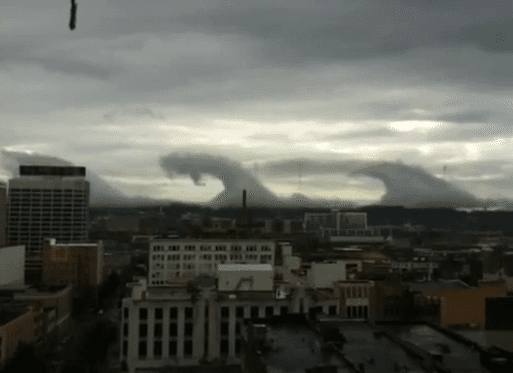
Frequent visitors to the society Cloud Gallery will be familiar with the beautiful and dramatic ‘Kelvin-Helmholtz clouds’, which look like a series of breaking waves and often appear in a line of beautiful vortices. Normally, these formations are spotted amongst mid-level or high clouds, and so are only noticed by cloudspotters who make a point of looking up. We made Kelvin-Helmholtz wave clouds worth 55 ‘cloud-collecting points’ in our reference book The Cloud Collector’s Handbook, in which you get point for the different clouds you spot (UK version of the book is here, US version is here). This is the highest points of all the clouds types in the book, since it is rare and fleeting formation that is easy to miss.
But not all examples of Kelvin-Helmholtz clouds are this elusive. Some recently appeared in the skies over Birmingham, Alabama, US, which no one could have missed. These wave clouds were so low in the sky, and had such prominent breaking-wave shapes that they stunned locals. The dramatic waves soon flooded the media, newspapers and Internet. They became known as the ‘Alabama tsunami clouds’.
The world may have been stunned that breaking waves can appear within the clouds like this but bit members of the Cloud Appreciation Society. They have been sending in their amazing and beautiful Kelvin-Helmholtz cloud photographs for years.


I saw Kelvin-Helmholtz clouds off the coast in Pacifica, California last week (around Feb 2 or 3). I had seen pictures of the Birmingham ones in the news, so when I saw them here I recognized them immediately. These were much higher in the sky, though, and smaller (maybe further away) and were over the Pacific Ocean, in the southern sky. There was a line of perhaps 8 or 9 waves, which dissipated over a period of about 20 minutes.
These clouds aren’t common!
I saw an interesting formation of Kelvin-Helmholtz, but it wasn’t so exciting as the video… ;)
I hope you received my photo of this event. I live in Birmingham, and I watched the entire thing unfold. The ridgeline you see in the video had been enveloped by fog all morning, and an advancing cold front sent laminar winds over the top of the ridge, resulting in the fog lifting off the mountain and forming the horizontal vortices you see. I watched it develop from a stable layer of fog, to “ripples” appearing, to the development of regular peaks, and then the appearance of the “breaking wave” formations. Not to sound immodest, but I’m pretty sure I was the first person in the city to hout “Kelvin-Helmholtz!” :)
beautiful clouds I like taking pictures and the clouds are essential. Greetings from Italy