
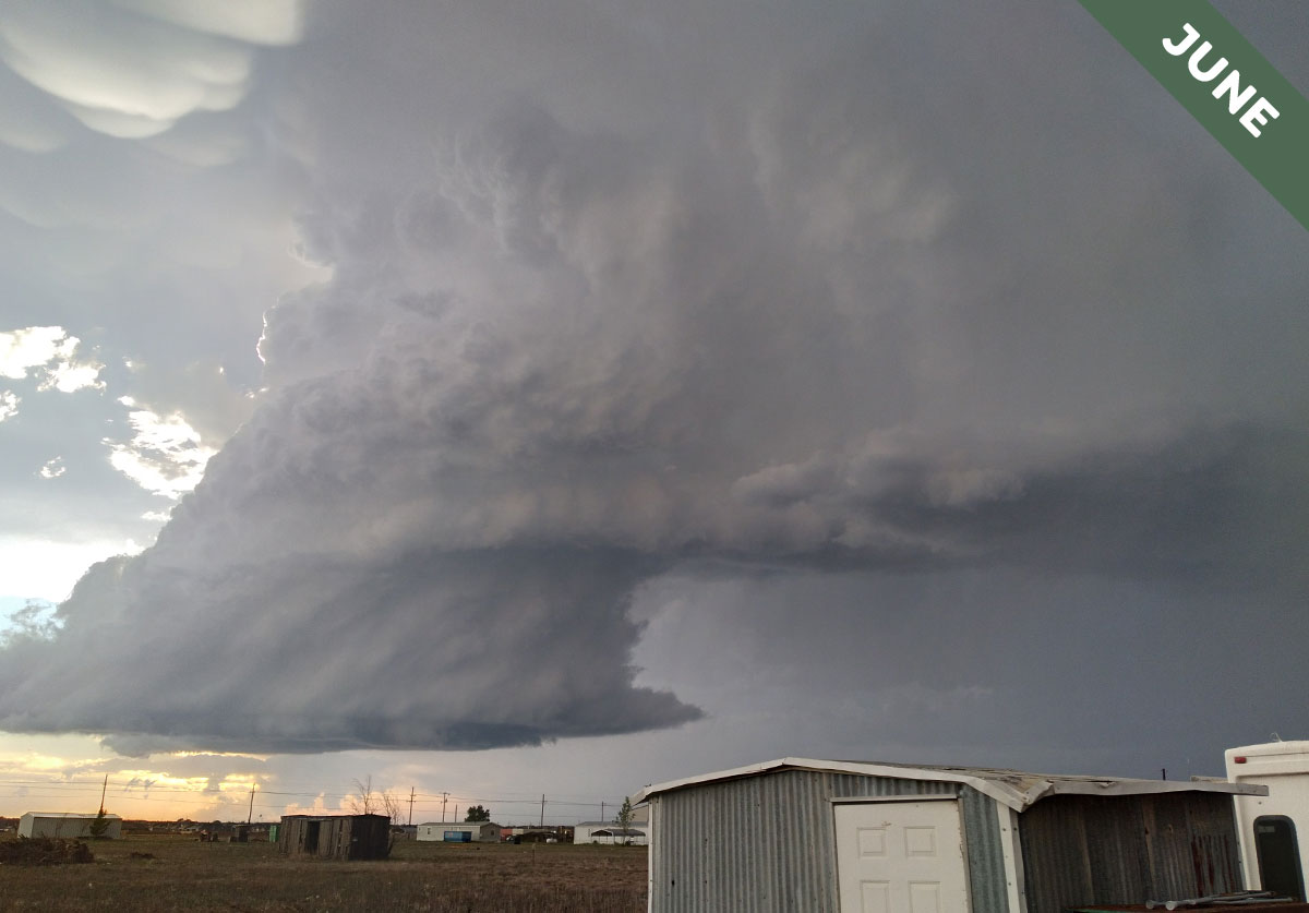
Murus – A Wall of Cloud
If you notice an abrupt lowering of part of the base of a mighty Cumulonimbus storm cloud, there’s a chance you’re looking at a murus formation, otherwise known as a wall cloud. This cloud feature, which was spotted in June’s Cloud of the Month by Terry Waller over Lubbock, Texas, US, appears as a broad column extending down from the base of a powerful thunderstorm. It is, in some cases, where tornadoes are born.
How the currents of air flowing into and out of a thunderstorm interact with each other determines whether a murus cloud forms at its base. You can think of these airflows in terms of updrafts and downdrafts. The updrafts consist of warm, moist air near the ground being sucked up into a Cumulonimbus thundercloud as it builds in height. Downdrafts, on the other hand, consist of cool, moist air dragged down by all the precipitation within the storm, splaying out and away from it as it reaches the ground. The opposing flows of air, upwards and downwards, often directly meet, one weakening the other and thereby weakening the thunderstorm as a whole. But when the opposing flows of air are separated out into different sides of the system – something that can happen when the towering Cumulonimbus cloud is tilted sideways by fierce cross winds up at its top – they no longer oppose each other. This separation of updraft and downdraft, of inflow and outflow, means the storm can become extremely powerful, and it is key to the development of a murus formation.
The feature appears where moisture is drawn into the air rushing up through the base of the Cumulonimbus. This, remember, due to the storm’s slanting shape, is at a different side of the cloud to that where the showers are falling – it is known as the storm’s ‘rain-free base’. But the rain-soaked air that has splayed out from the showers is never far away, and this can get sucked back into the updraft, bringing extra moisture, which is the fuel of any building storm. This extra moisture leads to cloud developing more readily in the up-rushing column, lowering the cloud base in this part alone and forming the distinctive murus cloud feature. You can sometimes see the moisture being drawn into the updraft from the precipitation region when it appears like a tail of cloud extending from the murus. You can see this tail forming to the right of Terry’s murus. It is another storm cloud feature which is known as a cauda, or inflow tail cloud.
While murus features can form beneath any thunderstorm with the right separation between its up- and downdrafts, they’re most impressive when associated with rotating thunderstorms known as supercells – the sort that is featured in Terry’s photograph. The most powerful form of storm system, a supercell, has an updraft region arranged as a massive rotating column up its middle, known as a mesocyclone. The murus feature is the base of this rotating column of up-rushing air and so can be seen to rotate. If the system stays well organised and the mesocyclone keeps rotating for long enough, eventually tubas can appear at the base of the wall cloud – ropes of intensely spinning cloud reaching downwards that can develop into fully-fledged tornadoes. Thanks to the murus cloud feature, staring at a wall can sometimes be quite exciting.
Murus cloud feature spotted beneath a Cumulonimbus supercell storm system over Lubbock, Texas, US by Terry Waller.

I think this is the entire meso you’ve got here?