
Radar shows lake effect
- This topic has 0 replies, 1 voice, and was last updated 8 years, 3 months ago by
 .
.
Viewing 0 reply threads
Viewing 0 reply threads
- You must be logged in to reply to this topic.
Forums › The Cloud Forum › Radar shows lake effect
Tagged: radar lake effect
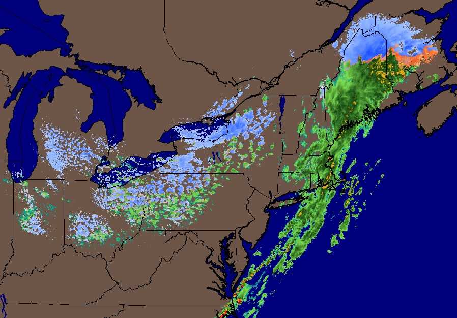
I have not seen radar images in the forum, so here is something different. Radar does not see clouds, rather it sees precipitation. I can talk a bit about how radar works and what it can see, but that would be boring. Instead, I hope I can get you to appreciate some pretty pictures or some impressive ones.
Lake effects are one of my favorites. This is the NE of the US. Cold air is flowing in from Canada from NW towards SE. As it passes over the not-so-cold Great Lakes, it picks up moisture which becomes precipitation downwind.
Those patches look like altocumulus, but the real clouds, I suspect, are thick stratocumulus or nimbostratus. The images are enhanced to indicate snow, rain or mixed precip (blue, green, orange/pink).
| Cookie | Duration | Description |
|---|---|---|
| aelia_cs_selected_currency | 1 day | This cookie is used to enable the currency selector functionality of our website. |
| aelia_customer_country | session | This cookie is used to enable the currency selector functionality of our website. |
| cookielawinfo-checkbox-advertisement | 1 year | Set by the GDPR Cookie Consent plugin, this cookie is used to record the user consent for the cookies in the "Advertisement" category . |
| cookielawinfo-checkbox-analytics | 11 months | This cookie is set by GDPR Cookie Consent plugin. The cookie is used to store the user consent for the cookies in the category "Analytics". |
| cookielawinfo-checkbox-functional | 11 months | The cookie is set by GDPR cookie consent to record the user consent for the cookies in the category "Functional". |
| cookielawinfo-checkbox-necessary | 11 months | This cookie is set by GDPR Cookie Consent plugin. The cookies is used to store the user consent for the cookies in the category "Necessary". |
| cookielawinfo-checkbox-others | 11 months | This cookie is set by GDPR Cookie Consent plugin. The cookie is used to store the user consent for the cookies in the category "Other. |
| cookielawinfo-checkbox-performance | 11 months | This cookie is set by GDPR Cookie Consent plugin. The cookie is used to store the user consent for the cookies in the category "Performance". |
| PHPSESSID | session | This cookie is native to PHP applications. The cookie is used to store and identify a users' unique session ID for the purpose of managing user session on the website. The cookie is a session cookies and is deleted when all the browser windows are closed. |
| viewed_cookie_policy | 11 months | The cookie is set by the GDPR Cookie Consent plugin and is used to store whether or not user has consented to the use of cookies. It does not store any personal data. |
| Cookie | Duration | Description |
|---|---|---|
| __utma | 2 years | This cookie is set by Google Analytics and is used to distinguish users and sessions. The cookie is created when the JavaScript library executes and there are no existing __utma cookies. The cookie is updated every time data is sent to Google Analytics. |
| __utmb | 30 minutes | Google Analytics sets this cookie, to determine new sessions/visits. __utmb cookie is created when the JavaScript library executes and there are no existing __utma cookies. It is updated every time data is sent to Google Analytics. |
| __utmc | session | The cookie is set by Google Analytics and is deleted when the user closes the browser. It is used to enable interoperability with urchin.js, which is an older version of Google Analytics and is used in conjunction with the __utmb cookie to determine new sessions/visits. |
| __utmt | 10 minutes | Google Analytics sets this cookie to inhibit request rate. |
| __utmz | 6 months | Google Analytics sets this cookie to store the traffic source or campaign by which the visitor reached the site. |
| peepso_last_visited_page | 30 minutes | This cookie is used by the Community pages of our website to remember the last page you visited. |
| Cookie | Duration | Description |
|---|---|---|
| CONSENT | 16 years 3 months 7 days 8 hours | YouTube sets this cookie via embedded youtube-videos and registers anonymous statistical data. |
| sbjs_current | 5 months 27 days | This cookie is to identify the source of a visit and store user action information about it in a cookies. This is a analytic and behavioural cookie used for improving the visitor experience on the website. |
| sbjs_current_add | 5 months 27 days | This cookie is to identify the source of a visit and store user action information about it in a cookies. This is a analytic and behavioural cookie used for improving the visitor experience on the website. |
| sbjs_first | 5 months 27 days | This cookie is to identify the source of a visit and store user action information about it in a cookies. This is a analytic and behavioural cookie used for improving the visitor experience on the website. |
| sbjs_first_add | 5 months 27 days | This cookie is to identify the source of a visit and store user action information about it in a cookies. This is a analytic and behavioural cookie used for improving the visitor experience on the website. |
| sbjs_migrations | 5 months 27 days | This cookie is to identify the source of a visit and store user action information about it in a cookies. This is a analytic and behavioural cookie used for improving the visitor experience on the website. |
| sbjs_session | 30 minutes | This cookie is to identify the source of a visit and store user action information about it in a cookies. This is a analytic and behavioural cookie used for improving the visitor experience on the website. |
| sbjs_udata | 5 months 27 days | This cookie is to identify the source of a visit and store user action information about it in a cookies. This is a analytic and behavioural cookie used for improving the visitor experience on the website. |
| vuid | 2 years | Vimeo installs this cookie to collect tracking information by setting a unique ID to embed videos to the website. |
| Cookie | Duration | Description |
|---|---|---|
| IDE | 1 year 24 days | Google DoubleClick IDE cookies are used to store information about how the user uses the website to present them with relevant ads and according to the user profile. |
| test_cookie | 15 minutes | The test_cookie is set by doubleclick.net and is used to determine if the user's browser supports cookies. |
| VISITOR_INFO1_LIVE | 5 months 27 days | A cookie set by YouTube to measure bandwidth that determines whether the user gets the new or old player interface. |
| YSC | session | YSC cookie is set by Youtube and is used to track the views of embedded videos on Youtube pages. |
| yt-remote-connected-devices | never | YouTube sets this cookie to store the video preferences of the user using embedded YouTube video. |
| yt-remote-device-id | never | YouTube sets this cookie to store the video preferences of the user using embedded YouTube video. |
