
[vc_row row_type=”row” use_row_as_full_screen_section=”no” type=”full_width” text_align=”left” background_animation=”none” css_animation=””][vc_column][vc_column_text]
Cloud Rush Hour
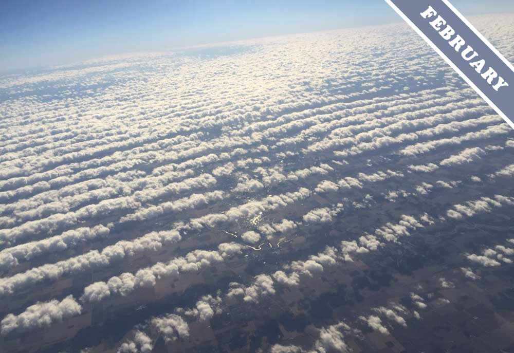
Cumulus clouds have to put up with tailbacks just like we do. Bumper-to-bumper low Cumulus like these spotted over Union, Indiana, US by Beth Fluto (Member 44,081) are known as ‘cloud streets’. Their more official classification would be Cumulus radiatus, on account of how the long lines of clouds, when viewed from below, appear to radiate from a point on the horizon due to the effect of perspective.[/vc_column_text][/vc_column][/vc_row][vc_row row_type=”row” use_row_as_full_screen_section=”no” type=”full_width” text_align=”left” background_animation=”none” css_animation=””][vc_column width=”1/2″][vc_column_text]Cloud streets are always aligned with the wind. They run parallel to the wind direction. This differentiates cloud streets from the similar-looking low formation known as Stratocumulus undulatus, which always runs perpendicular to the wind. So why do these two distinctive cloud formations line up in different directions? Because the two clouds patterns, though similar in appearance, develop in quite different ways.
The lines of Stratocumulus undulatus clouds run perpendicular to the flow of air because they develop in what are known as ‘shearing winds’. This is when the windspeed increases markedly with height. It can lead to a sort of ‘ruffling’ of the air between, coaxing it into wave-like ridges of rising and dipping air, like a rug bunching up as it is slid along the floor. Not only are the lines of these clouds perpendicular to the wind, they also tend to appear as more continuous stripes of cloud compared with the serried ranks of individual Cumulus in cloud streets.[/vc_column_text][/vc_column][vc_column width=”1/2″][vc_single_image image=”259007″ img_size=”full” add_caption=”yes” alignment=”center” onclick=”link_image” qode_css_animation=””][/vc_column][/vc_row][vc_row row_type=”row” use_row_as_full_screen_section=”no” type=”full_width” text_align=”left” background_animation=”none” css_animation=””][vc_column][vc_column_text]Why, then, might Cumulus clouds arrange themselves into ‘streets’ like February’s Cloud of the Month? Cumulus generally form on invisible thermals of air rising off the sun-warmed ground, and they stay small like these ones when they form beneath an invisible lid on cloud growth, known as a temperature inversion. This is to do with the way air temperature changes with altitude. When there is a steady, broad and continuous flow of wind, the Cumulus developing beneath the invisible lid of temperature inversion naturally arrange themselves into lines of lifting thermals, where the clouds form, and sinking air where they don’t.
While the clouds look as if they’re crawling along in the worst multi-lane tailback imaginable, remember that fair-weather Cumulus are the most lighthearted and friendly of cloud types. As a result, incidents of cloud-street rage are almost unheard of.
Cumulus radiatus, or cloud streets, spotted over Union, Indiana, US by Beth Fluto (Member 44,081).[/vc_column_text][/vc_column][/vc_row]

The photos are amazing, thank you. Always learning.