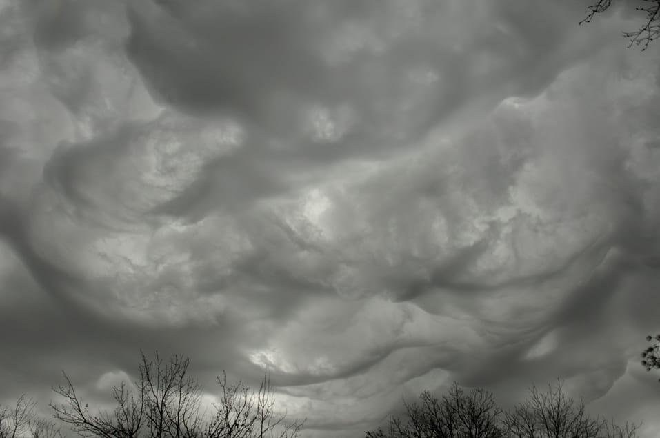
If you have spotted an example of this cloud, and you have a photograph with an accurate date, time and location we would love if you could email the image to us so that we can add it up to the society photo gallery. The more examples we have of this cloud formation, the stronger our case for the term being made official.
There is nothing new about the cloud formation itself, but we feel that it does warrant a new name, since it doesn’t easily fit within the existing terms. Our proposed name, ‘asperatus’, comes from the Latin word for ‘roughened’, because the cloud looks rather like a choppy, rough sea. The term is now in common usage, but it will only become official it it is included in the World Meteorological Organisation official cloud classification manual, The International Cloud Atlas. The last edition they published was back in 1975, but there are rumours that the UN organisation is considering the case for publishing a new edition. If this goes ahead, we will be lobbying for asperatus to be included. It would be the first new cloud term to be added to the classification system for 60 years.
> Read more about the asperatus cloud here…
> See examples of asperatus on the Society photo gallery here…
> See a piece about asperatus on The Weather Channel here…
> And if you think you might have photographed one, please email us your photo — and please try to include the most accurate date, time and location of the sighting that you can.


Have seen these few times at summer here in Finland.
Seem to appear in cloudy/overcast weather but haven’t had any bad weather, rain or notable surface winds with them.
This definitely deserves own classification. That very three dimensional cloud bottom with wave like structure just doesn’t resemble any other clouds. It looks so weird that it makes typical Kelvin-Helmholtz look almost normal.
Here is a time lapse of these clouds that I recorded earlier this year. http://youtu.be/-qKHuSlcywo
And here are the same clouds flipped up side down. This makes the clouds look like wave on the sea. http://youtu.be/EpgXm36rnk8
I have seen an asperatus cloud system a couple of times. One I saw at the Faroe Islands in 2011 was special.
By the way, i have several times tried to submit a photo to your gallery, but haven’t seen it there yet. The photo shows a cloud looking like an eagle. I have also taken many other interesting photos of clouds that would fit your gallery. But why send any of them when I don’t get “the eagle” cloud in the gallery?
Where I live, in the outskirts of Bergen, Norway, I often see many beautiful and interesting clouds. I have also sent some photos to Mr. Anderson in Met Office in England. Last year I even got one photo published in the quarterly magazine “Weather.” so I hope also The Cloud Appreciation Society would approve my cloud photos one day!
Kind Regards
Henrik Kolden, Norway
J’ai vu ces nuages à La Tranche sur mer (France) le 17 aout 2011 à 7h30 du matin, j’ai été très impressionnée ; cela ressemblais à d’enormes carapaces de tortue !!! C’était tres impressionnant comme irreel…
I saw these fairly often in Oklahoma. While they look threatening, there was seldom any rain, high wind, or other bad weather while these were in the sky.
I saw these clouds for the first time about 20 years ago in the Seattle area. They covered the sky, appeared to hover low, were amazing, and looked like up-side-down mountains. I’ve spotted these new clouds in various forms since, mostly in the last five years, but none have been so well formed as the first ones. I’ve taken many digital photos of them. I’ve wondered if the earth from the ground up is emitting something new and different into the atmosphere to produce them, like stirring your finger in a pan of soapy water.
Cloud formations like these are not new. When in the Navy in the Western Pacific in the 1960’s and rough weather was pending, we saw these several times. I now live in Florida and they are not rare here either, especially this time of year (hurricane/rainy seasons). I think the fuss is about our ability to record accurately and communicate instantly what we think are “new” phenomena that have been here all along but were rare enough not to be burned into our memories. And remember, sailors’ tales usually were not believed: monster squids, great rogue waves, etc., until in the case of squids we found enough examples or in the case of the rogue waves, satellites proved the case for us sailors whose tales were to be disbelieved. It is nice to have new nomenclature for such an interesting cloud formation. Thank you.
I saw cloud formations like these over Northland, New Zealand, in 1990. They struck me as weird at the time. I have some movie images of them on an old Video-8 tape, date stamped 29:12:1990. The images aren’t wonderful but, I’ll send them to you once I’ve worked out how to get them off the tape into an email-able format!
This cloud reminds me of paintings by William Blake!
I have be fascinated by pictures of the beautiful, ominous undulatus asperatus. However, I am equally fascinated by the response from you and from the media. It seems to reflect the sort of society we live in, which is concerned almost exclusively with appearance and image and newness. Nowhere have I heard or seen any reference to what these formations might MEAN. After all they are there because of what is happening in the atmosphere around our precious planet, they are not there as decoration!
during most of the the year 2000 i saw this type of cloud in mid wales. the village of Forge near machynlleth has a road connecting it to the town and a good view of the sky…no buildings. I walked the road so often with the sky looking like that it felt like being in the beginning of a disaster film.