Forum Replies Created
-
AuthorPosts
-
 Sarah SturgisParticipant
Hariklia, this is a beautiful beautiful. In the background it looks like cumulus congested. But in the foreground is a classic example of altocumulus castellanus. Your photo shows them perfectly, with no interference by attached clouds. They are also far enough above the background clutter to stand out against the blue sky. Congratulation. That is a magnificent catch.
 Sarah SturgisParticipant
Hariklia, this is a beautiful photo. In the background it looks like cumulus congested. But in the foreground is a classic example of altocumulus castellanus. Your photo shows them perfectly, with no interference with attached clouds. They are also far enough above the background clutter to stand out against the blue sky. Congratulations. You’ve made a magnificent catch.
June 24, 2023 at 11:52 pm in reply to: Amazing sky from top of the hills with a thunderstorm approaching! #576345 Sarah SturgisParticipant
Those are some gorgeous photos, Marie!
 Sarah SturgisParticipant
Sorry. I don’t see fluctus. The curl reminds me of the Kelvin – Helmholtz phenomenon, but those usually come in a parade. I don’t think that’s it.
 Sarah SturgisParticipant
Neat photo, Flynn. Looks like radiatus to me, as well. Your photo reminded me that the cloud systems can be multilayered.
 Sarah SturgisParticipant
James,
What a spectacular photo, no matter what the cloud formation is. The background sky transitions from light to dark, so, at the horizon, the clouds appear dark against the lighter sky. At the top, the clouds appear lighter than the saturated dark blue background. Lovely. There is a roundish look, an optical illusion, I think, that suggests mamma.
The cloud formation looks like altocumulus floccus, to me.
 Sarah SturgisParticipant
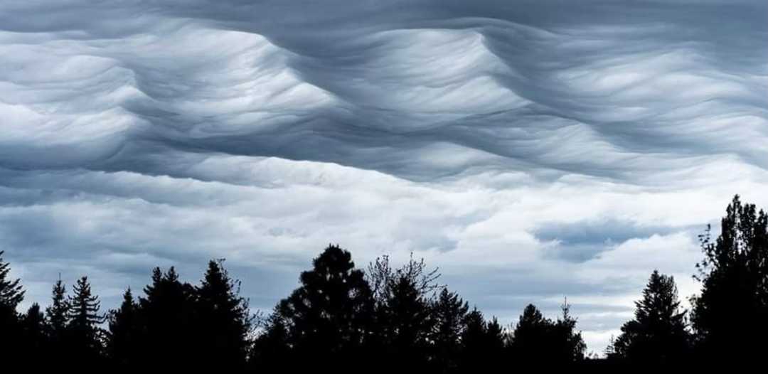
This is a photograph taken by Eric Loz, showing a classic example of Asperatis.

 Sarah SturgisParticipant
Marie, A linear parallel pattern of undulatus is implied in places. I see it, too.
Undulatus clouds form in the low pressure troughs between the rolling, parallel waves in the ocean of air below. They are long, straight, parallel clouds of the same altitude. Here the undulatus have become strato- and alto- cumulus in the unstable atmosphere. The parallel pattern persists, though, in spots with less turbulence. What looks like “a roughened sea surface from below,” is the “chaotic, wave-like configuration forms at the base of stratocumulus or altocumulus clouds” [The International Cloud Atlas] This cloud type is called Asperatis.I’m not positive of this classification, but present my suggestion with information about Asperatis.
Asperitas was added to the International Cloud Atlas in 2017. It was the first new classification of cloud in 54 years. In 2009, the Cloud Appreciation Society petitioned the World Meteorological Association to officially name this cloud type. Our group is referred to as “citizen scientists”.
 Sarah SturgisParticipant
To me it looks like cumulus conjestus, the darkness of it suggests a lot of cloud stack above. Though it can’t be seen, I suspect a building cumulonimbus rises from the dark part. I don’t see any spreading fine high clouds as from an anvil top.
 Sarah SturgisParticipant
Looks like it in the left. Sorry I don’t have more to add
 Sarah SturgisParticipant
Those photos are spectacular, Flynn. I’m no expert, but when cumulus is rising to become cumulonimbus, it begins as a gang of cumulus, cumulus congestus, Perhaps you’re catching an upwards view of the entourage, the remaining congestus. Mamma churns across the underside, suggesting energetic internal convections, rising and falling on the inside of the growing cumulonimbus. Maybe you’ve caught a hybrid. In any case, WOW, what a catch, with the rosy side lighting. Thanks for sharing this gorgeous enigma.
 Sarah SturgisParticipant
Wonderful photo. It looks like asperitas, but more linear and less woven than more common Asperitas. I get why you questioned it.
 Sarah SturgisParticipant
I’m no expert, but I’m old and allowed to pretend I am. What an interesting topic. If contrails are disallowed, what are those two lit clouds? The lighted clouds would need to be on two different layers, with different wind directions. On a third lit layer, far above, are some high, directional cirrus that seem unrelated to the linear clouds in question. A fourth layer, low and in the dark, shows wispy stratus. They seem unrelated as well. I can’t think what those clouds might be accept contrails, which was my first impression.
 Sarah SturgisParticipant
Those sure do look like kelvin-hemholtz. I’m not an expert, just an avid cloud watcher. I vote yes.
-
AuthorPosts


