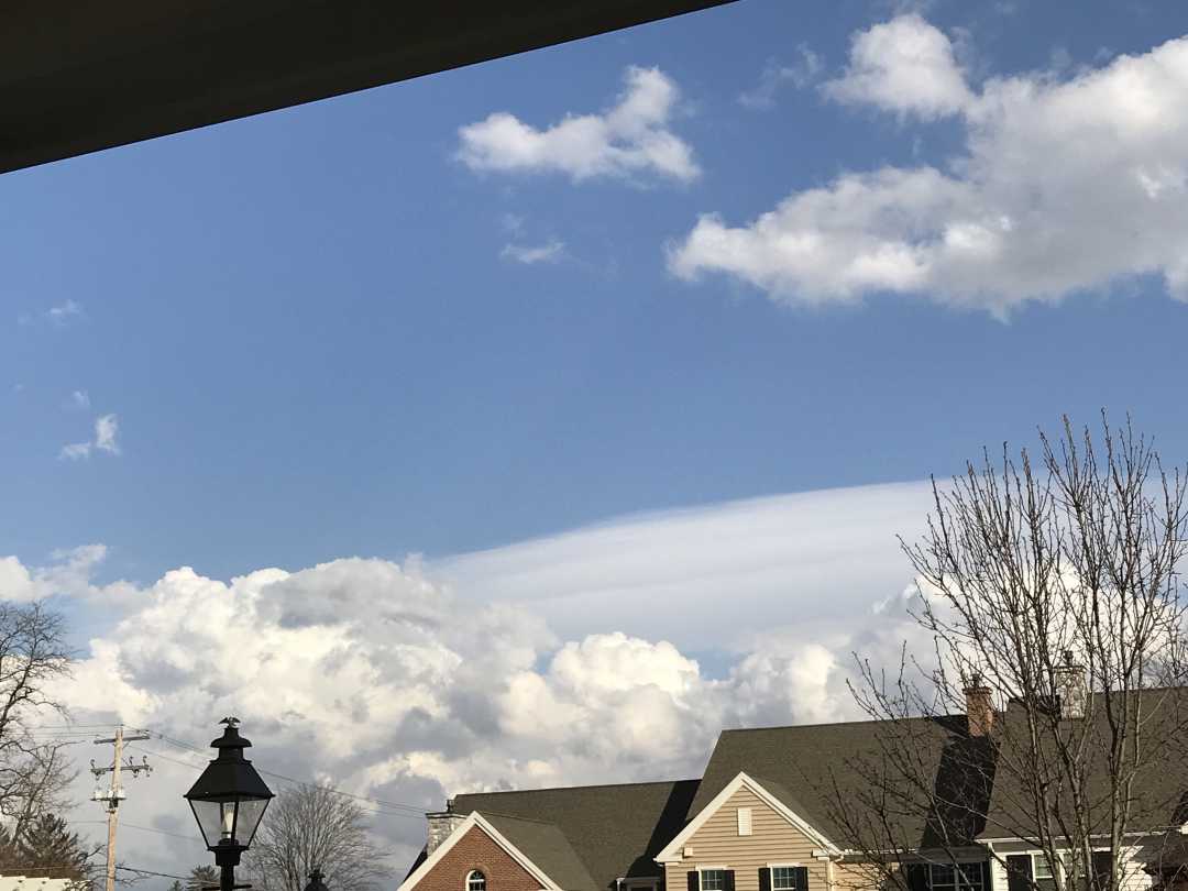
Is this the same type of cloud as today’s (March 16)?
Forums › The Cloud Forum › Is this the same type of cloud as today’s (March 16)?
Tagged: Cloud types, harbinger clouds, storm clouds
- This topic has 6 replies, 3 voices, and was last updated 7 years ago by
 Emily Klenin.
-
AuthorPosts
-
-
March 16, 2019 at 2:45 pm #334481
 Emily KleninParticipant
-
March 16, 2019 at 11:30 pm #334564
Howard Brown
ParticipantKlenin you have a knack for asking enigmatic questions (I am still awaiting details of those paintings in Oslo).
As for this one – a fine picture, with several cloud types, but….
Anyway, welcome back.
-
March 18, 2019 at 7:53 pm #334866
 Emily KleninParticipant
Hello, and thank you, I’m glad I’m back and that I’m welcome and that you like my picture. I didn’t mean to be enigmatic, it’s just that the Cloud of the Day for March 16 was a *very* intimidating arcus being pushed ahead of a very dark storm, while *my* clouds don’t look at all the same, although in a way they should: blue sky notwithstanding, it rained furiously and at length only five minutes later. I really would like to know how to label the white stuff in the picture, and I have no idea. We have always had lots of rain and so lots of clouds here (rural central Pennsylvania, US) but never, ever such vast shifts of weather so quickly — twenty degrees in temperature over a few hours, winds twenty mph bringing in a completely new weather and then dropping to deadly still for half a day. Overall half again as much rain as normal, according to those who keep the records. So the clouds are noticeably different from in earlier years, much more ephemeral, and more exotic, compared to the little fluffies we used to have. Since Welsh, according to the March 14 posting, has so many different kinds of rain, perhaps we should all go back to speaking that that tongue, once in use here but not in many years. Anyway, I keep photographing the clouds here, just because I like them, and they’re here and so am I.
-
March 18, 2019 at 10:47 pm #334888
 Michael LerchParticipant
K.. The puff clouds above roof tops are cumulus congestus. The smooth cloud behind them and higher is a lenticular at altocumulus heights and the clouds at top of picture but nearest to camera are cumulus humilis,in my humble opinion.The congestus were probably responsible for the rain. Have fun!
-
March 18, 2019 at 11:13 pm #334893
Howard Brown
ParticipantKlenin, sorry, I tend not to see Cloud of the Day – I should have realised.
Michael, a thought – is it possible your lenticular (heading to the top of the tree on the right) is old velum having formed under the congestus and now drifting away?
-
March 19, 2019 at 11:56 pm #335067
Howard Brown
ParticipantKlenin, some questions which might point to lenticularis if the answers are yes
* is there high ground upwind of the cloud
* was the atmosphere stable (perhaps not if it rained 5 minutes later)
* did the cloud stay still rather than drift with the wind
-
-
March 20, 2019 at 12:45 am #335077
 Emily KleninParticipant
<p style=”text-align: left;”>Actually it was that cloud that was really puzzling me. I hadn’t noticed the shape of the bottom. When I have seen lenticular clouds right next to cumulus they usually look at least as if they are roughly the same height, and I don’t usually see them in town here, more often in the countryside. There is always high ground upwind at the spot where I took the pic, though, because the town is in a hollow surrounded by hills. The cloud stayed still long enough to have its picture taken but was shortly overtaken by the storm from the west (I was facing east and a little north) — it wasn’t terribly windy, but all the clouds were moving at a pretty good clip. I really appreciate your taking the time to think about this and explain what could be going on — I ‘m afraid I am considered quite the eccentric among my more practically minded neighbors. So thank you!</p>
-
-
AuthorPosts
- You must be logged in to reply to this topic.


