
Lenticularis and Rotor Clouds – the Rough with the Smooth
The iconic mountain cloud called lenticularis is known for its disc-like shape (it’s named from the Latin for a ‘lentil’) and its smooth, sculpted texture. A lenticularis often looks like it’s been chiselled smooth from bright-white marble by skilled Renaissance sculptors. The rotor cloud, which often appears alongside a lenticularis, looks quite different: rough and clumpy. Surprisingly, these two very different clouds form in similar ways, with the help of mountains.
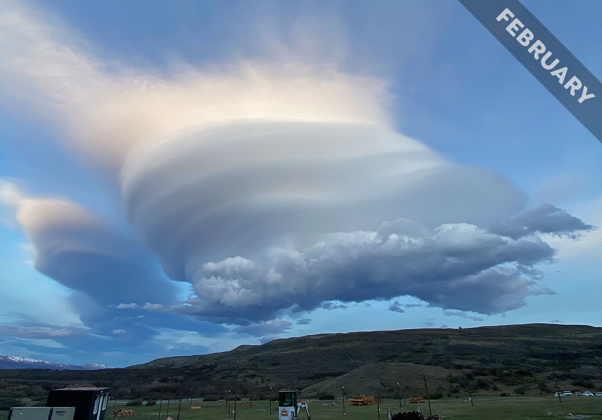
James Ewart spotted lenticularis and a rotor cloud downwind of the peaks near Torres del Paine National Park in Patagonia, Chile. The lenticularis clouds are in the middle and in the distance to the left, while the rotor cloud is just in front of the base of the nearer lenticularis.
These clouds develop as air flows over mountains, and they need stable, not showery, conditions to form. This is when the air gets colder gradually and steadily with altitude – or may even warm a little as you rise. Such stable atmospheric conditions mean that air tends to sink back down after it is pushed upwards. And that’s where the mountains come in.
Raised terrain, whether mountains or hills, act as enormous obstacles to the wind, pushing air upwards as it flows over. And when conditions are stable, the airflow sinks back down beyond, sometimes rising and sinking in a wavelike pattern downwind of the peaks. At the crests of these standing waves of air, moisture carried in the airflow can cool enough to condense into lenticularis clouds.
Because the air rises and dips in a smooth way and the lenticularis appears only at the altitude where the air has cooled enough, this cloud appears smooth and disc-like – echoing the peak that gave rise to it. Sometimes lenticularis, like James’s here, have a stacked appearance when the smooth-flowing air has moister and drier layers. But the air downwind of mountains in stable conditions doesn’t all flow smoothly like this, and that’s where rotor clouds come in.
These are effectively tumbling forms of Cumulus or Stratocumulus that appear in a churning region of air down beneath the smooth lenticularis-forming waves of air. The pattern of air pressure nearer the terrain in the lee of the mountains can cause the lower air to be lifted and turned over in a churning flow below and just beyond the smooth waves above. These powerful, often invisible, eddies pose a serious danger to aircraft, and so pilots avoid flying anywhere near the underside of a lenticularis cloud. If the low air drawn up into these eddies contains enough moisture, tumbling, dynamic rotor clouds appear. They’re an atmospheric reminder that you must take the rough with the smooth.
Altocumulus lenticularis duplicatus and rotor clouds over Torres del Paine National Park, Patagonia, Chile spotted by James Ewart. View this in the photo gallery.

This has just astonished me because I’ve been trying to identify clouds like these all day! A couple of days ago, we had exactly these in the Swiss Alps at sunset. Now I know, thank you! I will post mine, northern hemisphere twins.