
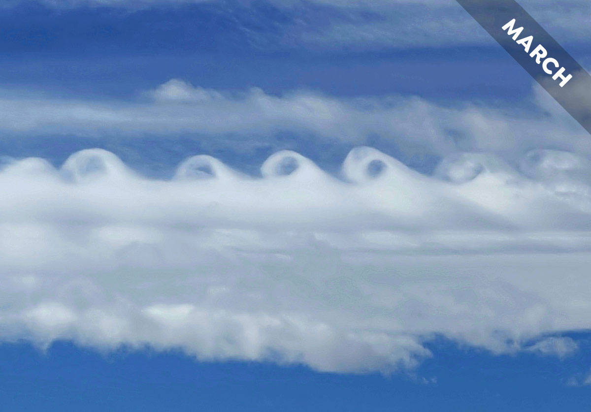
Altocumulus fluctus – The Curly Cloud
The fluctus cloud feature looks like a breaking ocean wave. The distinctive shape is always short lived, tending to dissipate within five minutes or so. Fluctus forms along the top of a cloud – often just as a solitary curl but sometimes as a succession of curls, one after another. That’s what Patrick Dennis (Member 3,544) spotted along the top of a patch of Altocumulus near Brighton, Colorado, US. Patrick was looking out over the Rocky Mountains, and a mountain range like this helps explain why these distinctive cloud features form.
Fluctus develop along the top of a cloud that has formed at the boundary between two rather different layers of air. Typically, the layer above the cloud is warmer, and so less dense, than the air in which the cloud formed. Cooler, denser air beneath warmer, less dense air is considered a stable region of atmosphere. That’s because any part of the cloud that’s lifted up for some reason will tend to sink back down to where it started. This is part of what explains the appearance of fluctus cloud features. The other factor is known as wind shear.
This is when the winds above and below the cloud, at the boundary of differing air layers, flow at different speeds or in different directions. Though we don’t usually see contrasting winds like this, they are common. The winds at one level can flow this way while the winds just above flow another, or they might be flowing considerably faster above than below. This wind shear ruffles the top of the patch or layer of cloud, causing it to be whipped up into undulations. The crests can be pulled into peaks if there’s enough wind shear and the stable conditions help to curl these back down over like ocean breakers.
How, then, are the Rocky Mountains involved in forming Patrick’s fluctus? The peaks near to Brighton, Colorado can reach up into the mid-levels of the troposphere – up to the sort of altitudes where Altocumulus clouds form. Air interacting with terrain like this is slowed down as it swirls around the peaks and valleys, but higher airstreams flow unimpeded. The mountain terrain helps set up the very wind shear needed to produce these cloud features. This is why any view out across mountains is a great place to look for the rare and fleeting curls of the fluctus cloud.
Altocumulus fluctus spotted over the Rockies, near Brighton, Colorado, US by Patrick Dennis (Member 3,544). View this in the photo gallery.
