
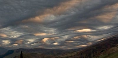
Members and visitors might remember that a couple of years ago we proposed that a new classification of cloud should be added to the official classification system. Photographs of this cloud formation had been sent in by Society members over the years, and we’d never known quite how to classify them since we felt that they didn’t easily fit into the existing cloud terms.
The cloud looks a little like the surface of the sea on a choppy day, which is why we proposed that it should be called asperatus from the Latin verb ‘aspero’, meaning to make rough. The term was used by Roman poets to describe the sea as it was roughened by the cold north wind.

Asperatus clouds over the Lofoten Islands, Norway. © Ragnhild M Hansen
No sooner had we proposed asperatus as a new cloud type than the story ‘went viral’, becoming one of those news stories that just spreads through the world media. News pieces appeared in the UK, the US, online and in many other contries. It was even nominated as one of Time Magazine’s 50 best inventions of 2009.
We felt all this press attention was a little premature as there hadn’t even been time to look into the atmospheric conditions that give rise to the cloud formation. But all the publicity did lead to a huge number of people sending in their own photographs of asperatus clouds they’d spotted, greatly adding to the growing asperatus collection.
Soon, the term was being adopted by cloudspotters around the world. But we always thought it a pretty unlikely to ever be accepted as an official term. This, we were were told by our friends at The Royal Meteorological Society would only happen if it were acknowledged by the World Meteorological Organisation in Geneva, who publish the rather dry but thorough bible of cloud classification, The International Cloud Atlas.

Asperatus over Schiehallion, Perthshire, Scotland. © Ken Prior.

Graeme Anderson's asperatus dissertation.
By studying the weather records and using a computer model to simulate the cloud, Graeme found evidence that asperatus is formed in the sort of conditions that produce mamma clouds (also known as mammatus), but when the winds up at the cloud level cause it to be sheared into wavelike forms known as undulatus. The conclusion was that there was a case for this being accepted as a new classification – one that is called a cloud ‘supplementary feature’.
The Royal Meteorological Society is now encouraging the international meteorological community to update the Cloud Atlas and include asperatus to make it official. The current edition, after all, was published in the 1970s. If asperatus is accepted, it will be the first official cloud classification in 60 years.

Recent sightings over Chicago.
We will keep you posted if there is any news about the World Meteorological Organisation deciding to go ahead and update the classification system.

The first time I saw these type of clouds was in 1987 in Ohio. We have pictures of them. It was right before a huge storm. I always wondered if they were related to mamma cloud, and it’s cool to find out that they probably are!
Never in my youth did I see clouds like this.
Giving Latin names to cloud formations that are HAARP induced is the creation of a new science, where there is no science whatsoever, only treason and the poisoning of the earth.
We saw some in Brussels(Belgium)today.
Marvelous article on this strange cloud type. I have seen these in the southern Cascade Mountains in Washington around MOunt Adams.
I’m not sure exactly why but this site is loading very slow forr me.
Is anyone else having this issue or is it a issue on my end?
I’ll check back later and see if tthe problem still exists.
Pretty great post. I just stumbled upon your
blog and wished to mention that I’ve truly loved surfing around your weblog posts.
After all I will be subscribing for your rss feed and I hope you write again very soon!
Having read this I thought it was really informative.
I appreciate you finding the time and energy to put this information together.
I once again find myself spending a lot of time both
reading and posting comments. But so what, it was still worth it!
I just like the valuable information you provide to your articles.
I’ll bookmark your blog and test once more here regularly.
I’m moderately sure I’ll be told plenty of
new stuff right right here! Good luck for the next!
Agree with Sally that many of these newer clouds seem caused by pollution, destruction of the ozone and atmosphere, and climate change – and we’re likely to see more weird sky phenomena when the Arctic ice melts – another HAARP “experiment.”
These clouds may have been common in some areas, but that they are now being seen in new areas with different conditions screams HAARP and weather manipulation to me. I’m sure there are many Sci-fi fans who have no awareness of chemtrails, that is left for enviromentalists and people who are interested in what is happening in the world to investigate. If you want to give them a name why not Van Gogh clouds, I’m more interested in what they are, not getting them named. I certainly don’t appreciate man-made pollution in our skies.
On 25th January 2012 I spotted what can only be described as Asperatus Clouds in Doncaster, Victoria, Australia. I took many photos should you be interested. I remember the day being warm with a top of 79 degrees F (26C), with gusty winds.
Today in Flint, MI I believe I spotted some. I have several photographs. Interested in knowing if they are the new cloud asperatus formations.
Sorry for the typo.
I have seen theses before, in Georgia and maybe in Oklahoma. I photograph clouds on a regular basis for use in junior college science classes, I will see if I can find examples.
Have a picture of cloud formations like this taken on 2 August 2013, no geoengineerng involved. I find the idea that these clouds were geoengineered quite funny.
This was nature at its best, they were preceeded by multiple thunderstorms, I’ll have to upload it on here.
Totally agree with Bonnie, Matt & Billie – have been a skywatcher all my life and these weird NEW cloud formations have only occurred since the onset of all the geoengineering experimentation – which IS going one and is admitted in government documents available online – although admitted that most of the testing is carried out in secrecy: ‘We
consider that a ban, even a short-term ban, on all SRM geoengineering testing would prevent work on geoengineering as “Plan B”. It may well also be unenforceable and be counter-productive as those carrying out tests do so in secrecy.’ (House of Commons Report on Geoengineering 2010) What baffles me, is why so many organisations, environmental groups and interest groups such as this one – fail to acknowledge or accept that our climate now is man-made! Man should stop interfering with Nature in such drastic ways because Nature will always win! Who wants to gaze up at such oppressive and malignant skies?
Delightful and many thanks to Graeme Anderson for his diligent work — a great contribution to the cloud collection!
Thanks Dave so glad there’s at least 1 person that can see through the bulls**t, if you don’t know what HAARP is or what it is capable of you have been living under a rock piled very high with lies, only the ignorant have no idea. Thanks ‘cloud appreciation society’ for not knowing the difference, please do your due diligence and do some research.
This is common in Australia when they cover the sky with geoengineering chemtrails. You can measure large amounts of anomalous ionisation during these times which is caused by the ground-based RF for the purpose of controlling the weather. Not a new cloud, just weather manipulation.
Saw clouds like this about a month ago over Cardiff. Unfortunatly was on my way to work so no camera with me.
Since you are clouds professionals, I would like to share with you all something that my grandma taught me — if she is still alive she will be 136 years old in 2013 !! She said that when we see red clouds in the morning, there will be rain at the evening. If you see red clouds in the evening, there will be sunshine the next morning !! I found it is 100% accurate in Malaysia and China. What about in your country ??
Love the photos that you took, I love to watch the clouds when I was young !! We saw human,animals, trees and all sorts of art in the sky !! So pretty !!
This is my image share. Taken on March 24, 2012 in the town of Clay, New York. It was lightly raining on and off. Other than that, I don’t recall much other stormy weather. http://img.photobucket.com/albums/v51/Kim2002/PhotosbyKimHill/2012-03-24_09-55-26_53_KimHill_zpsb927a948.jpg
edit your stuff first. “this we were were..”
Great show this AM above Fort Worth, TX of this cloud formation. absolutely stunning and a tad bit creepy. I’d never seen anything like it, and was able to capture a number of shots after dropping my son off at school.
Some of these clouds are pretty like Scotland but the one in New Zealand looks wicked scary!
I question some of this and open to look at HAARP. Wouldn’t ignore the possibility
i have some photos of so called asperatus clouds that i took a week ago ..would you like me to send them to you ?
When you do the research on chemtrails, HAARP, and Geoengineering, you will most likely come to the same conclusion that many of us have: the government is conducting their “secret” projects as they have always done and we the people are their test subjects. When government scientists say “Oh, yeah, we might conduct spray operations in the future to ‘stop Global Warming’ with Geoengineering, but we’re not doing it yet,” they are lying.
Brand new cloud formations never seen before? WHY? Has anyone figured that out yet? If you have been standing underneath a sky of “Asperatus clouds” you might just feel the creepiness closing in on you. This is NOT natural. Wake up people, before it is too late. Stop going along with everything the government tells you and try thinking for yourself. All you have to do is take some time to research this for yourself and you will be shocked.
The Norway photo is stunning. A very similar Asperatus sky appeared over Michigan’s capitol on Sept. 25, 2012. Will send photos. Wishing you success in achieving official recognition for this cloud type.
I’ve been a avid weather watcher since the 70s, and have noted that, at least in New England, Asperatus seems to be associated with certain weather types. I’ve seen it when a vigorous deep low and active occluded fronts are moving in and there is little lower cloud. They move quickly and are associated with a cool surface temperature. Secondly, they can form in the cool maritime air north of coastal lows moving off the coast of New England. I have never seen them connected with any thunderstorms or thunder regimes or humid air masses (at least when I’ve viewed them). Always seems to be cool air.
Hey I just happened to catch something about this potential new cloud classification, and thought as a more or less lifetime resident of Anchorage, Alaska we see this type of cloud on a fairly regular basis, both in Anchorage, and all over the Kenai Peninsula. I would bet with a minimum of effort many, many pictures of this new cloud could be obtained from local networks, residents, and of course the huge number of tourists that come through this area.
Just saw these type of clouds outside in Southeastern, KY.
They scared me at first. Amazing!
Wow! I’ve always loved cloud formation but todays airing of the Perthshire Asperatus photo in the Daily Telegraph has introduced me to the ‘Cloud Appreciation Society’! I will certainly sign up. The picture is almost sinister, exciting too…
I was with my friend Bridget at Worth Matravers on August 27 when we spotted the cloud formation – I thought it looked spooky and ominous and had certainly never seen anything like it before. It proved to not be ominous, soon cleared up, and the sun came out an hour or so later.
A friend of mine and I spotted low asperatus clouds while driving near Worth Matravers on the Dorset coast on 27 August and pulled the car over as I had never seen anything like this before. I likened them at the time to a ruched marquee lining when seen from one angle.
I have images and will join in order to post.
Great photo, and lovely cloud formation. The story hit the Independent today, and was reviewed in the newspaper review on Sky News last night: http://www.independent.co.uk/environment/nature/a-new-cloud-on-the-horizon-8165969.html
I blogged it on my site, which also supports cloud appreciation from a different angle:
http://www.greenygrey.co.uk/blog/?p=5455
And looking at some of comments a few people need to get out more and stop watching too much syfy.
Seen this sort of cloud formation myself over the years. I shall have to try and take a picture next time.
I observed some interesting clouds like these in the Chicago area on June 29, 2012. I have photos on wunderground dot com, search LarrySmit.
On May 27 riving north toward Huntsville Ontario Canada on Highway 11 my husband and I were a little spooked and worried when we saw the sky in front of us completely covered from east to west with this canopy of weird undulating clouds that looked like high mountains and valleys. Have never seen this kind of formation before. It was during a time of very unsettled weather (rain hail and eventually tornato warnings unusual for this area). Came online to see if anyone else had seen anything like these clouds and found your website. Thanks…. felt like we were witnessing the apocalypse!!!!
well, Honza, why just sit and stare at freaky, doomsday-like brown bumpy skies like the one over Schiehallion shown in the picture, wondering what the hell you’d like to call the freakier one that’s coming tomorrow.. just go for it, hitch a ride on a piper, and fly your way through it next time you see one! And needless to say.. don’t forget to take deep breaths when you’re there ;)
is this connected to the electro magnetic field being pulled? NASA put out info about it in 2009 around the same time this started happining
oh come on dave, you watch too much of X-Files… Consipration everywhere… can’t you just stop, take a deep breath, take a look above and enjoy what nature offers?
ohhh….for sure, asperatus clouds are great…..you mean HAARP clouds?
you think it’s great that our leaders are dumping chem trails over us in the sky?
poisoning us with harmful chemicals that they drop from planes to interrupt natural weather patterns?
you think it’s great that they cover up their senseless, cold blooded acts with little fluffy good meaning terms like “asperatus clouds?”
we’re not little kids who can believe this and believe me, they’re not getting away with this, these pigs are going to get what they’re giving three fold, and I’m going to laugh when it’s going down
Asperatus! I have seen one, and I’ve looked in vain for any sort of classification. It didn’t look at all like the pictures of wave clouds. I really couldn’t believe my eyes, but now I see the first picture posted here and that’s more dramatic but still very similar to the deep black waves I saw. But I didn’t see them anywhere particularly exotic – they were to the south of the very unromantic Phipps Plaza (a shopping mall!) in Atlanta, GA. about two years ago…
I have seen and photographed these types of clouds before, but never so sensually as in these photos from Scotland and Norway. It’s probably most likely to appear there because of the turbulence off the Northern Atlantic with the convergence of the Arctic Air with the (somewhat) warmer air from the Mid-Atlantic.
Whatever causes them doesn’t matter though, as they are gorgeous atmospheric events despite cause or explanation.
I had my first sighting of this formation on 10th June on the Isle of Wight. The island has a very interesting climate with some smaller micro-climates at various locations around it, which give a huge variety of clouds. I hope that you do get this recognised.
Wow … I`m speechless about such a sky … Thanks very much for showing this!!!
Great News for the Asperatus effort!..I have been absolutely thrilled at every Asperatus sighting . When turning a photo of an Asperatus event upside down, one can see the ” undulatus” effect. Supplementary feature or not, the phenomena is real, so godspeed to the WMO recognizing it. I sincerely hope the tenacity of the originators of the Asperatus effort pays off soon.
Simply incredible. I have yet to witness firsthand any such wildness in the sky. I have seen my fair share of awesomeness, but the examples that are shown here, are just simply incredible. I will be a Cloudian until the day that such is no longer possible. Thanks Gavin, Thanks Ian… Thanks Mother Nature…. May your sky’s allways be filled with beauty. Bryan Hightower. Member # 7929