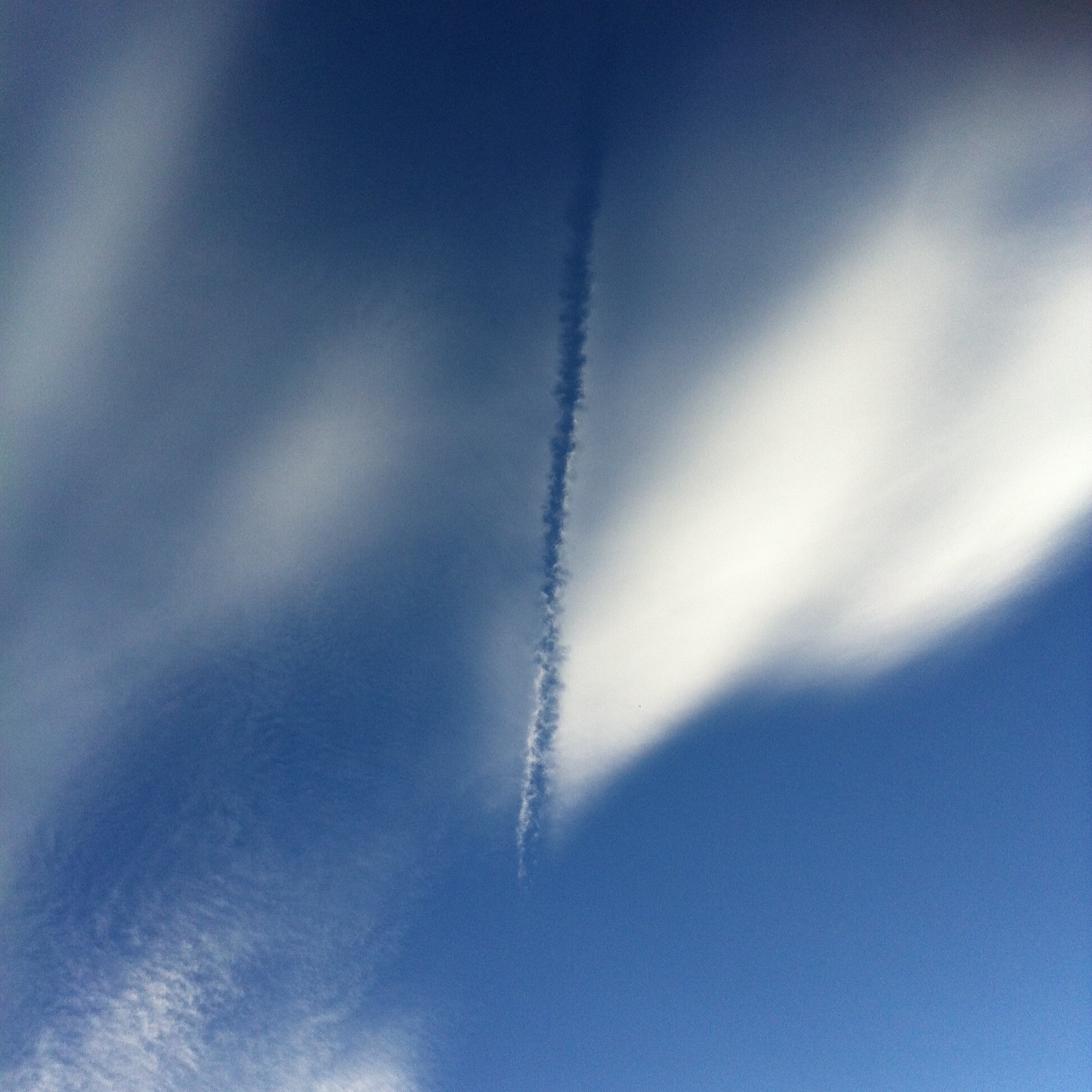
Family: Other Cloud Types

Murus

The low block of cloud that can appear at the highly turbulent inflow region of a large storm is known as a murus, or wall cloud. The feature develops at the back of an advancing storm, like its rear bumper, or fender, marking the region where no precipitation is falling but instead strong updrafts of warm, moist air near the ground are being sucked up into the storm, fuelling its growth. With such a rush of up-flowing air, a wall cloud is liable to sprout ‘tubas’, rotating fingers of cloud that descend from its base when the airflows develop spin. The murus feature at the storm’s rear is therefore, the breeding ground for landspouts, waterspouts and fully-fledged tornadoes. Tail-gating this particular cloud is not recommended.

Fractus

When Stratus clouds or Cumulus clouds appear as broken fragments, they are known by the species fractus. And while all example of fractus clouds are united by their frayed, shred-like appearance, they can form in a number of quite different ways.

Cumulus fractus is the more straightforward. This is when a fair-weather Cumulus cloud is just beginning to form or is in the process of dissipating away. In both cases, the cloud lacks the crisp outlines and solid appearance of a fully-fledged Cumulus, looking instead rather more wispy and translucent. When viewing photographs, cloudspotter have been known to confuse Cumulus fractus with the high, wispy trails of ice crystals known as Cirrus.The distinction is clearer viewing the cloud in reality, since the fractus formation is much lower and soon changes either into Cumulus or just clear air.

The fractus form of Stratus tends to appear in two contexts. One is in the form of dark shreds beneath a raincloud. This form of Stratus fractus has the more specific name of pannus. The other appears as wisps of cloud snagging on hillsides, where they catch in the trees, forming as damp air gently ascends up the slopes.

Pannus

Don’t get too excited about adding pannus to your cloud collection. When you do spot one, you’re likely to be rather underwhelmed, for they aren’t good-lookers. Loitering in the saturated atmosphere just below rain clouds, they resemble some sort of cloud version of hoodies, killing time outside McDonald’s on a Saturday night. These dark shreds of cloud, strictly classified as a type of Stratus fractus, give the sky a threatening air. The atmosphere below a precipitating cloud can become very humid, on account of all the moisture falling through it. Only the slightest rising gust can then cool the air enough for some of this moisture to condense into tiny droplets, which hang around as wisps of thin cloud.

If it is not raining or snowing when you notice dark shreds of pannus below a forbidding sky, you can be confident that it very soon will be. Pannus are the five-minute-precipitation warning of the cloud world.

As with the kids on the High Street, the sinister appearance of pannus clouds owes a lot to their surroundings. The shreds of cloud need only be thick enough to block a little light for our eyes to register them as darker than the thick, dark rain clouds above. Away from their precipitous context, pannus would be seen for the weedy wisps that they are. The same could be said of the prepubescent 14-year-olds, once stripped of their mates and hoods.

Velum

Like one of those tiny fish that swim in the slipstream of sharks, the accessory cloud known as velum is easily missed beside the mighty forms of its companion Cumulus congestus or Cumulonimbus clouds. It usually appears here as a thin, dark horizontal streak half-way up the side of the main cloud.

Named from the Latin for the sail of a ship, or the flap of a tent, velum are found in the vicinity of large convection clouds that have spread outwards for a time during their growth before breaking through and continuing their ascent. A strip of cloud is left behind, which lingers at the flanks of the towering mounds.

Despite their flimsy appearance, velum often hang in the sky long after the showy convection clouds that formed them have dissipated. We are sure there is a lesson hidden in there somewhere.

Congestus

Congestus is a towering Cumulus cloud – one that has developed in unstable atmospheric conditions and is well on its way to turning into a Cumulonimbus storm cloud. It is th largest of the three Cumulus species that describe the cloud’s size, the other two being the small Cumulus humilis and the medium sized Cumulus mediocris. Congestus can produce moderate showers but these are not as heavy or prolonged as those from it Cumulonimbus relative.

How do you work out when a growing Cumulus has reached the congestus stage? Compare the cloud’s height to its elevation above the ground. When a Cumulus has grown taller than the height of its base above the surface, you can be confident it has reached the congestus stage.

And what about distinguishing a Cumulus at the congestus stage from a fully-fledged Cumulonimbus cloud? This distinction is more subtle since congestus is the final stage of growth of a Cumulus cloud before it develops into the unruly Cumulonimbus beast. The point of change is all a matter of judgement and convention. The best rule of thumb is to pay attention to the cloud’s upper reaches. A Cumulus congestus may look tall and mighty, but its top still has crisp, well-defined edges. It is still like a huge version of a Cumulus. It is only considered to have changed into a Cumulonimbus when its upper region has ‘glaciated’. This is when all the droplets up there have frozen into ice crystals. When that happens, the edges of the cloud’s summit appear to soften. They begin to look much fluffier. This fluffy top is the sign the the mountain of cloud has transitioned into the mighty beast of the Cumulonimbus. Until that point, think of it as a Cumulus with a lust for power.

Pyrocumulus

When clouds form in the columns of air above forest fires, they are known as pyrocumulus. Anything hot enough to produce strong convection currents can give rise to clouds so long as there is enough moisture around. Large volcanic eruptions can lead to pyrocumulus clouds too. Either way, pyrocumulus can sometimes grow large enough to produce thunder and lightning or tuba cloud features that can develop into landspouts or waterspouts. The more technical name for pyrocumulus clouds formed over wildfires or volcanoes would be Cumulus flammagenitus and, when they develop enough to produce precipitation and lightning, Cumulonimbus flammagenitus (which people sometimes describe as pyrocumulonimbus).

Pyrocumulus can also form over the cooling towers of power stations. These too produce heat and water vapour, which when the air is cool enough can condense into droplets of cloud. Technically speaking, you’d call these manmade ones Cumulus homogenitus.

Forest fires, volcanoes and power stations also introduce countless microscopic particles into the air. These act as condensation nuclei – tiny seeds onto which the water droplets start to condense. With such a plentiful supply of these condensation nuclei, pyrocumulus tend to consist of very plentiful and small droplets. This, along with all the larger particles of ash or smoke, gives the cloud a very dense, sometimes yellowish, appearance.

Distrail

An aircraft dissipation trail, or distrail, is a specific example of the cloud hole known as a cavum, or fallstreak hole. In the case of a distrail, the cloud hole is formed by the passage of an aircraft through the cloud layer, and so it shaped more like a line than a circular hole.

As with a regular cavum, a distrail forms when very cold droplets in a cloud layer start to freeze in one region and fall below as ice crystals. If these dissipate away in warmer, drier air below the cloud, all that is left is a hole – or in this case, a line. An aircraft can trigger this freezing process by the cooling that happens within its wing vortices or by the tiny particles in its exhaust acting as ‘freezing nuclei’. Airborne particles, whether natural ones like dust, ash or plant material or ones introduced artificially like this, serve as the tiny seeds onto which cloud droplets can begin to freeze. Without them droplets can stay in ‘supercooled’ liquid state at temperatures as low as –40°C (–40°F).

Depending on whether or not the ice crystals evaporate in the air below, a distrail can appear as a completely clear line cut out of a cloud layer or one with a trail of ice falling crystals visible beneath it.

Castellanus

When a layer of cloud rises in distinct turrets with bumpy tops that resemble crenellations, it is of the species known as castellanus – and this one can give an early indication of unsettled weather to come later in the day.

The turrets of castellanus can be found at all three cloud levels, but the ones that are hardest to identify are in the high clouds, Cirrocumulus and Cirrus. As much as anything, this is because the cloud elements are so far away that they appear tiny from the ground, making any observation of the subtle nature of their tops rather challenging. Luckily, these examples of castellanus are also the least indicative of unsettled weather.

The low cloud Stratocumulus may be described as castellanus when at least some of the cauliflower mounds that form its upper surface have grown taller than they are wide. These rising turrets can sometimes continue to grow upwards and develop into rain-bearing Cumulus congestus, or even Cumulonimbus storm clouds.

But it is in the mid-level cloud Altocumulus that the jagged crenellations of castellanus are most recognisable, and also where they best forecast unsettled weather. The vigorous turrets show that the air at the mid-cloud level is unstable. Any Cumulus that start to develop on thermals and build up from below will, upon reaching this mid-level, continue growing with extra vigour, and quite possibly develop into tall, stormy Cumulonimbus clouds.

The castellanus term is never used to describe individual Cumulus clouds. When Cumulus grow tall like this, they are referred to as Cumulus congestus.

Floccus

When higher clouds are in small clumps or patches with very soft, fluffy edges, they are described as floccus. The name comes from the Latin for a tuft of wool, a piece of fluff, the little thing you find in your belly button. (Not the last one, actually). Floccus formations can be found up at the high-cloud level, as forms of Cirrus or Cirrocumulus, and at the mid-cloud level, as a soft looking, ice-crystal form of Altocumulus cloud.

Floccus clouds often have trails of ice crystals falling from them. For the lower examples, you’d describe these trails as virga. For the high examples of floccus, you wouldn’t – the trails are just another feature of the general cascade of ice crystals that we describe collectively as cirroform clouds.

Uncinus

Uncinus is a species of Cirrus where the streaks of the high cloud have a hooked appearance at one end. To be a true uncinus, these hooks should look like the handles of walking sticks, and should not take the form of rounded tufts or clumps. Those would be more likely to be the floccus form of Cirrus and trails of virga falling from Altocumulus.

Described in maritime folklore as ‘mare’s tails’, uncinus have traditionally been associated with the arrival of unsettled weather. There is some truth to the phrase ‘mare’s tails and mackerel scales make tall ships carry low sails.’ The hooked ends of these clouds indicate that strong winds up at the high-cloud level vary greatly with altitude – being much faster above the cloud than they are below. Such ‘shearing’ wind conditions do indeed herald the arrival of a weather front.

Asperitas

Asperitas is a rare formation that seems to form in the vicinity of Cumulonimbus storm systems. It can be thought of as an undulatus gone crazy. Asperitas differs from undulatus by the fact that its waves are more chaotic and disorderly, lacking any of the regularity and organisation typical of undulatus. The chaotic waves of asperitas have a more crisply defined base, which sometimes descends into pointed features, resembling upside-down peaks of meringue. When the waves cause varying thickness of the cloud layer, the sunlight passing through it can lead to dramatic patches of bright and dark.

This formation was only recognised as an official cloud classification in 2017, when the World Meteorological Organisation added it to the International Cloud Atlas, their official reference for cloud identification. It had first been proposed as a new cloud type by the Cloud Appreciation Society in 2008 and it acceptance as an official type was due largely to the examples submitted by members of the Cloud Appreciation Society.

Fluctus

The fluctus cloud, also known as the Kelvin-Helmholtz wave cloud, looks just like a series of enormous waves breaking on the shore. It is rare, fleeting and the favourite of surfing CloudSpotters. A well-defined fluctus is the crown jewel in many a cloud collection, for it requires the CloudSpotter to be blessed with eagle-eyed sky awareness and sheer blind luck. In one spotting alone, this cloud can help observers overtake their fiercest cloud-collecting rivals.

It appears at all three cloud levels, and can be thought of as a very specific example of the undulatus cloud variety, tending to be found in Stratocumulus, Altocumulus or Cirrus clouds. The distinctive curling waves can also sometimes be spotted along the top edge of a lenticularis cloud, a small Cumulus or even a layer of fog. In all cases, the formation lasts no more than a minute or two.

The breaking-wave appearance is caused by wind shear. When cloud develops at an abrupt boundary between layers of colder air below and warmer air above, and the upper layer is moving more rapidly than the lower one, undulations can develop along its upper surface. If the amount of shearing is just right, these undulations can roll up into a succession of vortices. The mechanism is rather different from that of ocean breakers, but fluctus cloud do look like a cloudspotting surfer’s idea of heaven.

Horseshoe vortex

What a subtle little wisp of cloud the horseshoe vortex is! It is easily missed by anyone other than the most keen-eyed CloudSpotter, intent on adding it to their collection. The rare and fleeting horseshoe vortex cloud appears for just a minute or so before evaporating. Anyone lucky enough to spot one must take a photo if they want to be believed by their cloud-collecting friends.

This cloud forms in a region of rotating air, or vortex. While the familiar orientation for a vortex is vertical (see the tuba cloud), they can occasionally develop on a horizontal axis. This is when the gently rotating crescent of the horseshoe vortex cloud can form. The movement of air seems to result from thermal that is sent into a spin as it reaches stiff horizontal winds above. Only rarely are conditions right for cloud to appear as the low pressure within this horizontal vortex causes the air to cool slightly. When they are, the twisting ribbon of cloud that forms is soon lifted upwards at its centre by the rising thermal, and distorts into a crescent shape.

This rare and beautiful little cloud won’t lead to any precipitation, but it will rain down luck upon anyone fortunate enough to spot it – as well as five CloudSpotter stars.

Nacreous

Forming 10–20 miles up, in the stratosphere, at –85˚C (-121˚F), nacreous clouds show beautiful iridescent pastel hues as they scatter the light from the Sun when it is just below the horizon.

Sometimes called ‘mother-of-pearl clouds’, their tiny, uniform ice crystals are very good at diffracting sunlight. This separates the light into bands of colour, to create a much more dramatic version of the iridescence sometimes seen in lower clouds.

Also known as ‘polar stratospheric clouds’ since they tend to appear over higher-latitude regions of the world, nacreous clouds are like a stratospheric version of the lenticularis species of wave cloud. They form when the atmosphere is so stable that waves produced as air flows over mountains down at ground level are transferred up through the atmosphere, and push moisture into the lower stratosphere. The best time of year to spot them is in winter, when temperatures are lowest.

Nacreous are known as Type II polar stratospheric clouds, and are made of ice crystals. There is another type of cloud up in the stratosphere, known as a Type I polar stratospheric cloud, which consists of droplets of nitric and/or sulphuric acid. These clouds are actually destructive for our environment. Their droplets act as catalysts that encourage the destruction of the protective ozone layer. They have only subtle, flat colouration, and so they’re not even described as nacreous clouds. Best stick, instead, with appreciating the harmless, colourful ones.

Noctilucent

The mysterious noctilucent clouds are higher than any other cloud in the atmosphere. Also known as ‘polar mesospheric clouds’, they have an eerie, bluish-white appearance, often showing delicate ripples or billows.

Noctilucent clouds form in the mesosphere, at altitudes of 30–50 miles (50–80 km) – almost at the limit of the atmosphere. Being so high means that, in the higher latitudes, where they are most frequently seen, noctilucent clouds shine out against the night sky well after the Sun has dropped over the horizon. They still catch the sunlight when the rest of the sky is dark. Their name comes from Latin for ‘night shining’.

Quite how noctilucent clouds form is by no means clear. The mesosphere is a region where air temperatures can be as low as –125˚C (–190˚F) but there is very little moisture at all. No one knows why the ice crystals that make up this cloud arise in such a dry and remote part of the atmosphere.

Historically, noctilucent clouds have tended to be spotted at latitudes higher than 50˚ during the summer months. It now seems that they are appearing over much larger regions of the world and more frequently. Some scientists have speculated that this change might be related to global warming.

The best times for CloudSpotters to try to add noctilucent clouds to their collections is a few hours after sunset or before sunrise from May to August in the Northern Hemisphere, and November to March in the Southern Hemisphere.

Pileus

Pileus is a fleeting and beautiful ‘accessory cloud’, which means it is only found attached to other cloud forms. It shares much in common with lenticularis and cap clouds, which form when a stable airstream rises to pass over raised ground. In the case of pileus, however, the obstacle is not rocky terrain, but something altogether more ephemeral – another cloud.

Pileus looks rather like a smooth, white beret, or, perhaps, a comb-over hairstyle. It is a horizontal cap cloud that appears momentarily on top of the crisp, cauliflower summit of a large Cumulus, or the softer one of a young Cumulonimbus. Pileus can appear as one of these large convection clouds develops upwards and encounters a moist stable airstream blowing above. This is forced to rise by the vigorous currents surging up the centre of the cloud below, cooling it just enough for some of its moisture to condense into droplets. These evaporate as the airflow sinks back down again past the convection cloud.

A pileus is prized by any cloud collector because, unlike its relation, velum, it never hangs around for long. Cloudspotters have to be sharp-eyed to add one to their collection. The vigorous convection cloud that made it inevitably continues its rise, pushing its bald head through the hairstyle.

Lacunosus

A rare, fleeting formation, the lacunosus variety is identified in terms of the gaps between cloud elements, rather than the clouds themselves. It is when a cloud layer is composed of more or less regular holes, around which fringes of cloud form, like a net or rough honeycomb. Even though lacunosus forms at all three cloud levels, it is an elusive prize for any cloud collector, since it is so short-lived.

The holes of this variety are formed by sinking pockets of air, and the cloud fringes around them by air rising up between the pockets to replace them. Such sinking can occur when a layer of cooler air finds itself over a warmer one. Being more dense, the cooler air sinks down through the warmer air. The appearance is similar to the rough honeycomb pattern you occasionally see on the surface of a hot cup of tea. As the tea on the surface cools and contracts, it sinks in pockets through the hotter tea below, which bubbles up in between to replace it. That said, no one is completely sure why sometimes the cool air sinks to form lacunosus, while other times the warm air rises in pockets to form the opposite arrangement of cloudlets with gaps between.

Tuba

The air below a storm cloud is often a wild confusion of blustery, gusty and not-at-all-tranquil winds. But when the storm develops from a single Cumulonimbus cloud into a co-ordinated system, known as a multicell or supercell storm, the mêlée of air currents becomes much more organised. This is when a tuba can form.

Resembling a cloud finger descending from the storm’s base, the tuba forms in the air sucked upwards into the storm to feed its vigorous vertical growth. Like an upside-down version of bath water going down a plug hole, the rising air can start rotating in a vortex. In a big storm cell, the rapidly rising air expands and cools enough for some of its moisture to condense to form the walls of the tuba. Also known as a ‘funnel cloud’, it can be the birth of a tornado.

A tuba can also form when the air is not rising but sinking from the base of individual clouds, such as Cumulus congestus and Cumulonimbus. Dragged towards the ground by the cloud’s heavy showers, this sinking air can cause vortices to form. These are rarely as violent as the upward ones, so tubas are less pronounced. They herald not tornadoes, but the less ferocious landspouts or waterspouts.

Whatever a tuba is heralding, keep your distance when adding it to your cloud collection – just in case it has a mind to add a CloudSpotter to its own collection of flying debris.

Mamma

‘What on Earth are those?’ is the usual reaction when people see photographs of mamma clouds. Also known as ‘mammatus’, these ‘supplementary features’ hang down from a layer of cloud in smooth or rough pouches that often have the appearance of udders (which is what ‘mamma’ means in Latin).

With such an otherworldly appearance, mamma are a must-have for any cloud collection. They can be found on a whole range of cloud types but the most dramatic examples occur on the underside of the huge anvils, known as incus, that spread out at the top of mature Cumulonimbus storm clouds and can cover all the visible sky.

Some claim that mamma are harbingers of stormy weather, and what with the association between these cloud pouches and Cumulonimbus, you might think they have a point. But mamma tend to form at the rear, rather than the front, of storms. Once you see mamma formations above you, the storm has usually passed over, or missed you entirely.

Each lobe of mamma is typically one to two miles across, and appears for around ten minutes. There are several theories about why they form, but an extensive 2006 scientific review of all the studies to date concluded that no one’s really sure.

Contrail

Before the start of the First World War and the advent of high-altitude flight, our skies appeared very different from the way they do today – there were no condensation trails, or contrails, which form in the exhaust of aircraft.

There’s no confusing these man-made clouds with the natural ones. Following the aircraft’s path, contrails tend to appear as long, straight slashes of white across the blue. In the vicinity of airports, however, they can sometimes form large loops, due to the stacking formation of aircraft waiting to land.

The length of time contrails remain in the sky – or indeed whether they form at all – varies greatly depending on the air conditions up at cruising altitude. When it’s cold enough and moist enough, the water vapour contained in the plane’s hot exhaust gases mixes with the very cold air to condense and form ice crystals. In some conditions, these soon evaporate. In others, they can persist for hours, the ice crystals absorbing water vapour from the surrounding air to grow in size and spread out in the high winds. In this way, contrails often encourage the formation of Cirrus, Cirrocumulus and Cirrostratus ice-crystal clouds.

Cavum

They look bizarre, but cavum, also known as fallstreak holes, are not actually that rare. They are crisp gaps in mid- or high-level cloud layers, below which dangle trails of ice crystals.

To form a cavum, the cloud layer must consist of supercooled droplets – when its water is in liquid form despite temperatures at cloud level being well below 0˚C (32˚F). This is actually quite common, for pure water suspended as droplets in the air behaves very differently from tap water in the freezer. If there aren’t enough of the right sort of tiny particles in the atmosphere to act as icing nuclei, on to which they can start to freeze, droplets remain liquid until temperatures drop to around –40˚C (–40˚F). They ‘want’ to freeze, but can only do so when there are seeds on which the crystals can begin to grow.

The fallstreak hole forms when one region of the cloud finally starts to freeze and begins a chain reaction. All the moisture from the supercooled droplets in the area rushes to join the ice crystals, which quickly grow big enough to fall below. A form of virga, the trail of ice crystals doesn’t tend to reach the ground, but evaporates before getting that far.

What starts the freezing? Sometimes it’s ice crystals falling into the cloud’s droplets from a higher Cirrus cloud. Most often, it is caused by an aircraft climbing or descending through the cloud to form a ‘distrail’. Low pressure in the vortices around the plane’s wings can cool the air enough to set off the freezing.

Radiatus

When a layer of cloud rolls or clumps extends in long lines that stretch off to the horizon, the effect of perspective makes these lines converge, like railway tracks, towards a point. Such a formation is a variety known as radiatus, and it can be found at all three cloud levels.

The parallel cloud lines form along the direction of the wind at cloud level. (When they form perpendicular to the wind, they are of the undulatus variety, rather than radiatus.)

Radiatus in low Cumulus clouds are known as ‘cloud streets’. These formations cause glider pilots to wet themselves with excitement, for they indicate avenues of lifting air along which the pilots can reliably gain altitude.

When it comes to high, ice-crystal clouds, the most dramatic examples of radiatus result from jet streams – the ribbons of 180mph winds that encircle the globe in the mid-latitudes at the top of the troposphere. Known as ‘jet-stream Cirrus’, these radiatus varieties of Cirrus can be spread over great distances by the high winds. Occasionally they appear to extend all the way from one horizon right overhead to the opposite one. The perspective causes the cloud rows to bulge dramatically above, while converging at ‘radiation points’ on each horizon. Such an impressive radiatus formation will be a source of great pride for any cloud collector but it is practically impossible to photograph in its entirety, since it stretches over such a large part of the sky.

Arcus

Storm chasers tend to have an abundance of arcus in their collections, for this formation, also known as a shelf cloud, is rather like the front bumper, or fender, of a storm cloud. It is a long, dark, horizontal roll or shelf running along the base of the storm cloud’s front edge (around the registration plate). So the shelf cloud is the first cloud feature to arrive as the storm runs you over.

Like those other brute-cloud groupies, tuba and incus, arcus hang out only in the company of hefty Cumulus congestus or Cumulonimbus clouds or those most brutish of all cloud systems, the fierce multicell and supercell storms. They form as the cold air that is dragged down by all the precipitation falling within the storm splays outwards upon reaching the ground. As it spreads around the storm, it burrows beneath the warmer, less-dense air at ground level. This is lifted most forcefully in the direction of the cloud’s movement, forming a ‘gust front’, in which the warmer air’s moisture can condense into water droplets that appear as the shelf of cloud.

More rarely, the lifting motion can cause a wave of rising and falling air that races ahead of the storm, causing a roll cloud, or volutus, which travels ahead of and separate from the storm.

Cap Cloud

A cap cloud tends to look like an enormous hat, perched upon the mountain’s head. Sometimes it looks like a humble skullcap. Other times, it splays out in a full mother-in-law-at-a-wedding extravaganza. Occasionally, the mountain seems to be wearing one hat on top of another, which is surely a mountain fashion faux-pas. Whichever it is, a cap cloud forms as a stable airstream rises to pass over a peak, cooling as it does so. It is a particular example of a lenticularis cloud, in which the cloud lies over the mountaintop, rather than downwind from it.

CloudSpotters should be careful not to add the wrong cloud to their collections. Clouds such as Stratus or Stratocumulus clinging to mountaintops won’t do. Only a smooth, jaunty cloud hat will count.

Virga

When you look up to find jellyfish floating above, you are either diving or beneath the cloud known as virga.

In essence, this is just a cloud raining or snowing, but with one important difference: the precipitation never reaches the ground. If the droplets or ice crystals (or anything between the two) fall through air that is warm enough and/or dry enough, they can evaporate before ever landing.

The appearance of virga from the ground is of trails that hang down like tentacles from a clump or layer of cloud, waving not in the currents of the ocean, but in those of the atmosphere. When virga occur below low-level clouds, they are composed of water droplets, and appear grey. When they consist of ice crystals, having fallen from mid- or high-level clouds, they have a much paler appearance. But beware: this distinction is a tenuous one, because our eyes judge colour and tone relative to the brightness of the background. The same trail of virga can appear whiter or greyer depending on the sky behind. Fallstreak holes are specific cases of virga falling from a layer of supercooled droplets to leave a hole behind.

When a cloud’s precipitation can be seen to reach all the way to the ground, it is no longer called virga, but ‘praecipitatio’.

Fog

The distinction between fog and mist relates to visibility. Officially, you can see 1–2km in mist but no more than 1km in fog – one’s just a thicker version of the other. Though fog is sometimes described as ground-level Stratus cloud, since that’s the lowest of the main clouds, it often forms quite differently.

Fog appears if air is cooled enough by its proximity to the ground or water surface for its moisture to condense into droplets. There are two main ways this cooling can happen.

‘Radiation fog’ forms after long, cold and clear nights. With no blanket of cloud cover to keep the warmth in, the ground quickly radiates the day’s warmth into the night sky, and can cool the air enough to form droplets. On higher ground, the cold, foggy air can sink downhill and gather as ‘valley fog’.

‘Advection fog’ occurs when air cools as it blows over a warmer surface to a colder one. If these are ocean surfaces, it’s called ‘sea fog’. Then there’s ‘steam fog’ – when cold air blows over warmer water, such as a lake, and the water vapour that evaporates off the surface instantly cools to form droplets.

That’s not the end of it. There’s also ‘upslope fog’, ‘hill fog’, ‘ice fog’, ‘haar’ and ‘frontal fog’. No matter which one it is, cloudspotters will never get closer to a cloud than when they’re enveloped in fog or mist.

Volutus

This is a long, low tube of cloud, which can appear to extend horizontally from horizon to horizon. Known more generally as a roll cloud, it often has a very smooth, silky surface. At other times, it can appear quite rough and bumpy. Volutus can move at speeds of up to 35mph (55km/h), with the roll appearing to rotate as it travels along. The direction of rotation is not as it would be for a solid tube rolling along the ground. In fact, the roll cloud rotates against its direction of travel – the cloud surface lifting at the front and dropping down at the back.

One famous volutus, the Morning Glory cloud, appears in Northern Queensland, Australia. This forms in a solitary wave of air and is caused by colliding sea breezes over the Cape York Peninsula. Volutus are often associated with sea breezes, and so they tend to be found in coastal waters. At other times, volutus are caused by storm systems. In this case they are rather like arcus, or shelf clouds, that have become detached from the storm system that produced them. As the storm dissipates, gusting winds of cold air can continue to spread out ahead of it, and form a roll of cloud that separates away from the rest of the storm.

Fibratus

The high, ice-crystal clouds of Cirrus and Cirrostratus are called fibratus when they have been drawn out by the wind into long, fine filaments. These close strands of cloud appear rather like hair run through with a comb. Such an orderly atmospheric hairstyle depends on high, continuous winds. These are more common up at Cirrus and Cirrostratus level, since the higher you climb through the troposphere, the faster the average wind speed becomes, and the less the wind is messed about by the influence of the ground.

The way to distinguish fibratus from the other Cirrus species that can also have somewhat parallel filaments, floccus and uncinus, is to look at the ends of the strands. In fibratus, the filaments do not descend from the fluffy tufts of cloud found in floccus, nor do they curve down from thicker heads to give the hooked, comma-like appearance of uncinus. Fibratus are simply thin, delicate strands of high cloud.

As expressions on the face of the sky, clouds can be indicators of the atmosphere’s moods, but not so in the case of fibratus clouds. Other than indicating high, continuous winds up at cloud level, they tell nothing of the weather in store. Perhaps they are just there to look nice.

Undulatus

When the surface of a cloud layer, or the arrangement of its cloudlets, develops an undulating appearance that suggests waves, it’s defined as the undulatus variety.

Waves and clouds have always had a close relationship. The interaction of currents in the atmosphere, and the effects of the terrain on the passage of winds, can result in a whole range of undulating currents of air. Generally, these are invisible, unless the rising parts of the undulations cool the air enough to produce clouds of droplets or ice crystals, which are thinner or absent in the sinking parts of the undulations. In such circumstances, the waves show up on the surface of the cloud or as cloud billows with gaps in between.

Undulatus usually forms when the air above and below the cloud layer is moving at differing speeds and/or in different directions. It is the shearing effect of the two airstreams that gives rise to the cloud billows, which form perpendicular to the wind direction and can resemble ripples on a sandy beach caused by the movement of water.

Wave formations in clouds are so common that the undulatus variety is within six of the ten main cloud types. Their presence is a reminder, to any who might forget, that the atmosphere around us is just as much of an ocean as the sea below.

Lenticularis

Lenticularis clouds are contenders for the Weirdest-Looking-Clouds-in-the-Sky awards. Their name is Latin for a lentil, on account of their very distinctive lens shapes. They often look remarkably like flying saucers. Presumably, when they were named, no one could think of the Latin word for ‘shaped like a UFO’.

Lenticularis can be found at low, medium and high cloud levels, although the most striking and dramatic ones tend to be the mid-level Altocumulus lenticularis. At whatever altitude they form, they are usually caused by a moist airstream flowing over raised ground, such as a hill or mountain peak. When the atmosphere in the area is stable, the air can develop a wave-like motion downstream, invisibly rising and dipping in the lee of the peak. If the air rises and cools enough, lenticularis clouds can appear at the crests of these waves. Unlike most clouds that drift along with the breeze, these hover even in the strongest winds (so long as air speed remains constant). Their positions in the airstream remain fixed, like the stationary waves of water behind a boulder in the current of a fast-moving stream.

When the airstream contains layers of moist air separated by drier air, a stacked formation can appear, known as ‘pile d’assiettes’ (which is French for ‘your turn for the washing up’).